Photo by Gordon Davies, 1966 (courtesy of Celia Nyamweru, Kenyatta University).
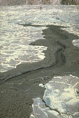
LengaiThe chemically exotic lava flows of Tanzania's Ol Doinyo Lengai volcano have unusually low temperatures and viscosities. Its lava flows are not incandescent during daylight hours. The flows are usually only a few cm thick and travel only a few tens of meters from their source. This 1966 photo shows a small lava flow, only a meter wide, with miniature channels and levees (note the person at the top for scale). Ol Doinyo Lengai is Earth's only volcano known to erupt carbonatitic (sodium carbonate) lava flows in historical time.
Photo by Gordon Davies, 1966 (courtesy of Celia Nyamweru, Kenyatta University).
Photo by Minoru Kasahara, 1991 (Hokkaido University).
NyamuragiraLava fountains from the new cone of Mikombe on the lower NE flank of Zaire's Nyamuragira volcano feed the lava flow in the foreground. This photo was taken from the SE on September 29, nine days after the start of the eruption. During the first week the new cone, whose name means "many bats," grew to a height of 60-70 m. Lava flows had traveled 6-7 km NE by the time of this photo. The eruption continued until February 1993, by which time lava flows had traveled 19 km to the NE.
Photo by Wally Johnson, 1988 (Australia Bureau of Mineral Resources).
BaganaBagana volcano, on Papua New Guinea's Bougainville Island, is characterized by the extrusion of thick, viscous andesitic lava flows. This dramatic photo shows a massive lava flow, bound by prominent lateral levees, descending from the summit and ponding against ruggedly dissected forested hills at the base of the volcano. Bagana is constructed almost entirely of overlapping lava-flow lobes. Slow lava extrusion, occasionally accompanied by explosive activity, has been continuing since 1972.
Photo by Norm Banks, 1984 (U.S. Geological Survey).
MayonA nighttime view from Legaspi City on September 14, 1984, shows incandescent lava flows descending the SW flank of Mayon volcano in the Philippines. The flows traveled about 4 km to the lower flanks of the volcano, adjacent to previous flows from eruptions in 1968 and 1978.
Photo by Dan Miller, 1990 (U.S. Geological Survey).
BezymiannyA black lava flow descends from the snow-mantled summit lava dome of Bezymianny volcano in Kamchatka in September 1990. The lava dome has formed during the past forty years both by expansion when new magma is intruded into the dome and by the extrusion of lava flows down its flanks. The dome has grown within a large crater, whose southern rim is visible behind the lava flow.
Photo by Lee Siebert, 1981 (Smithsonian Institution).
NewberryGlassy black obsidian is prominent in the Big Obsidian Flow erupted from Newberry caldera in central Oregon. The high-silica rhyolitic flow covers 20 sq km of the caldera floor. Obsidian flows are never entirely glassy, but also contain large amounts of frothy pumiceous material and devitrified spherulites, which commonly form bands alternating with layers of glass.
Photo by the Hawaii Undersea Research Laboratory (University of Hawaii).
LoihiSubmarine extrusion of magma produces a characteristic "pillow lava" morphology, as seen here on Loihi seamount SE of the island of Hawaii. Thin streams of molten lava are extruded in a form that resembles toothpaste squeezed out of a tube. The outer surface of the molten lava is quickly chilled by the water and solidifies, while the interior remains molten and continues to flow, lengthening the tubes. Lava flows with similar textures on land can be recognized as being uplifted submarine (or sublacustral) lavas.
 Large-volume lava flows are commonly fed through tubes beneath the crusted-over surface of the flow. The roofs of lava tubes frequently collapse, producing skylights, through which the flowing lava is visible. This October 21, 1970, photo of a lava flow from Mauna Ulu, at Hawaii's Kilauea volcano, shows several ledges within the lava tube that mark previous levels of flow. The walls and roofs of lava tubes are efficient thermal insulators that allow long-distance transport of lava. Some tubes during the Mauna Ulu eruption were 11 km long.
Lava flows are produced when magma reaches the surface and is erupted non-explosively. Basaltic lava flows, such as this September 1979 flow from the east rift zone of Kilauea volcano, are Earth's most common volcanic product. Basaltic lava flows have initial temperatures of about 1200 degrees Centigrade and a high fluidity. The volume, velocity, and travel distance of lava flows is related to silica content. More silica-rich lava flows have lower temperatures, are usually thicker, much more viscous, and travel shorter distances.
Two types of lava flows, pahoehoe and aa, are different textural forms of otherwise identical lava. The smooth-textured pahoehoe lavas (left) are formed by stable upwelling of gas-poor lava, whereas the hackly-surfaced aa flows are produced during eruptions with high lava fountaining of gas-rich magma. Eruptions of aa lava commonly evolve into sustained production of pahoehoe. Because of differential weathering rates, the overlying pahoehoe flows look younger than the associated aa flows, and the two flows are easily mistaken for flows of greatly differing age.
 An aa lava flow, with a characteristic hackly surface, advances across a smooth-textured pahoehoe lava flow. The front of this June 3, 1994, aa flow at Laeapuki, near the Puna coast of Kilauea volcano, is about 1 m high. Aa flows are produced by eruptions with high lava fountains of gas-rich magma. Eruptions producing aa lava commonly evolve into sustained eruptions of gas-poor pahoehoe.
The newly solidified surface of pahoehoe lava flows commonly has a silvery or irridescent color that is produced by recrystallization of volcanic glass as it becomes hydrated and oxidized. Pahoehoe lavas form during eruptions that are characterized by stable upwelling of gas-poor magma. This smooth-textured pahoehoe flow at Kilauea volcano was photographed in August 1994.
Photo by Paul Kimberly, 1994 (Smithsonian Institution).
Photo by Adrian Richards, 1952 (U.S. Navy Hydrographic Office).
BarcenaA steaming lava flow issuing from a fissure on the SE flank of Bárcena volcano, in the Revillagigedo Islands west of México, forms a peninsula about 300 m wide that extends about 230 m out to sea. This photo from the SE on December 11, 1952 was taken only 3 days after the beginning of lava effusion. By the time the eruption ended in February 1953 the lava delta had extended the shoreline by 700 m.
Photo by Jim Luhr, 1980 (Smithsonian Institution).
CeborucoThe braided El Norte lava flows cover most of the northern flank of Ceboruco volcano in western México. They were erupted along the ring fracture of one of the two nested summit calderas. The south wall of the inner caldera forms the far summit ridge. The andesitic El Norte flows blanket a 3.5 km length of the northern flank, and form a broad, 3.5-km-wide terminous at the base of the volcano. Their youthful morphology and unvegetated surfaces suggest a very young age, possibly during one of the two-16th century eruptions of Ceboruco.
Photo by Jim Luhr, 1983 (Smithsonian Institution)
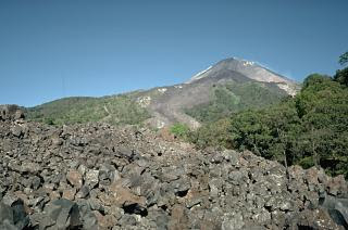
ColimaThe course of the block-lava flow in the foreground, which was emplaced during the 1975-76 eruption of Mexico's Colima volcano, can be seen descending through the vegetation at the center. The flow originated from the summit dome of Colima and traveled 3.5 km down the SE flank. The flow bifurcated on the upper slopes, forming another lobe that traveled to the east, forming the darker area that descends into the vegetation at the upper right.
.
Copyrighted photo by Dick Stoiber, 1963 (Dartmouth College).
Santa MariaA blocky dacitic lava flow that traveled to the SW from El Brujo vent of Santiaguito lava dome is seen in April 1963, a month after it ceased flowing. The slow-moving lava flow, which has a height of about 50 m, extended about 1.5 km from the vent. El Brujo vent, near the western end of the Santiaguito dome complex of Guatemala's Santa María volcano, is the youngest at Santiaguito and was the focus of increased effusive activity from 1959 to 1963.
Photo by Alfredo MacKenney, 1985.
PacayaSpatter cones form when blobs of molten magma that are ejected from a vent by mild explosions solidify around the vent and form a steep-sided cone. This small spatter cone formed in MacKenney crater of Pacaya volcano in Guatemala on February 10, 1985. This was part of an ongoing eruption of Pacaya that began in 1965. At the time of this photo, the spatter cone was 6-m high, ejected incandescent volcanic bombs from its vent, and issued lava from its eastern (left) side.
Photo by Jaime Incer, 1982.
MomotomboSuccessive lobes of the 1905 lava flow from Momotombo volcano in Nicaragua spread out on the flat slopes below the volcano, forming a broad terminus. Individual lobes diverted around slightly higher areas of the pre-eruption surface, surrounding these prominent forested "islands" of older rock, known as kipukas.
Photo by Marc Orbach, 1978 (courtesy of Tom Simkin, Smithsonian Institution).
FernandinaLava fountains from Fernandina volcano in the Galápagos Islands feed digitate lobes of lava in 1978 that travel across a down-dropped block of the NW caldera bench, about 380 m below the caldera rim. The 1978 eruption began on August 8, when a 6-km-high eruption cloud was visible from distant locations in the archipelago, and apparently ended on August 26. During the course of the eruption lava flows traveled 2 km into the caldera lake, more than 400 m below.
Photo by Marc Orbach, 1978 (courtesy of Tom Simkin, Smithsonian Institution).
Photo by Lee Siebert, 1978 (Smithsonian Institution).
SantiagoThe ropy texture of pahoehoe lava flows is produced when the thin solidified surface of the flow is pushed by the advancing, still-molten interior. This pleated pahoehoe lobe, on a lava flow at Santiago shield volcano in the Galápagos Islands, advanced slowly from the bottom right to the upper left. Pahoehoe lavas are the least viscous of common lava types, and thus form spectacular surface structures.
Photo by Hugo Moreno, 1989 (University of Chile).
LongquimayA 30-35 m thick, 1-km-wide steaming lava flow from Navidad cinder cone on the NE flank of Chile's Lonquimay volcano advances down the Río Lolco valley. By the time of this March 25, 1989 photograph, the flow had traveled about 7 km. Lava effusion began on December 27, 1988, two days after the beginning of an eruption that lasted until January 1990. The velocity of the slow-moving flow front decreased exponentially with distance from the vent. By the end of the eruption the lava flow reached 10 km from the vent and had a volume of 0.23 cu km.


No comments:
Post a Comment